The subject of this 1st blog post is towpath accessibility – which seems appropriate as my life now focuses on disability rights & access.
This issue of accessibility along the ‘substituted towpath’ section between Little Venice and Lisson Grove etc has been discussed in the past and was in fact the subject of a survey conducted by London Canals in 2006 which ascertained much needed to be done to bring this important link between the west London canal towpath and the central/east London canal towpath up to date with current legislation. This survey included wheelchair access, ramps, dropped kerbs and the other things that were clearly needed to bring this section up to scratch.
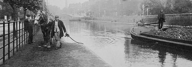
Blomfield Road towpath in 1905
The reason for calling it a ‘substituted towpath’ is because the original towpath, which was clearly 100% accessible, but now out of bounds for it serves as access to the many boats moored along this section of Blomfield Road.
London Canals published a leaflet (shown below) detailing the accessibility along this stretch which was stocked by British Waterways aboard Jena. On certain weekends in the summer there were leaflet holders placed by London Canals around Little Venice and Blomfield Road to help those needing the information to use the substituted towpath link between Little Venice towards Lisson Grove and Regent’s Park.
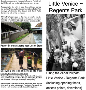
Little Venice to Regents Park leaflet pub by London Canals 2006-08
The purpose of the Little Venice – Regent’s Park leaflet was to give disabled people or families with kids and buggies the most convenient means of getting across the overland route (the substituted towpath) between those two points. It began at Paddington Basin and extended eastwards as far as the towpath access ramp at Charlbert Street bridge in Regent’s Park.
Despite some rudimentary signs placed at three or four strategic locations by British Waterways, no signage has ever been made for disabled people along this stretch of ‘towpath’. A survey made in January 2007 on the Maida Hill tunnel ‘overland route’ (as BW calls it) concluded the section should be signed for pedestrians and cyclists only. These proposals were pared back even further when intended signposts at several locations (including Edgware Road, shown below) were dropped.
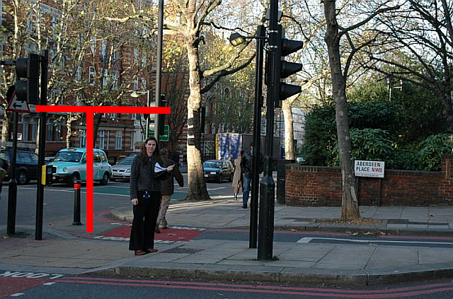
British Waterways during their surveys in early 2007
The above picture shows BW staff at Aberdeen Place/Edgware Road – with siting (marked red) for a signpost denoting the access route.
The stretch along Blomfield Road (and its counterpart Maida Avenue) has been very difficult to negotiate even for those walking and this year things were so bad that signposts were put up near the intersection with Warwick Avenue warning motorists of walkers using the road.
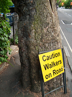
2014 – Sign warning motorists of walkers on road
One problem along this stretch is of course the boaters’ gardens, these are well maintained on the original towpath side however terribly unkempt along the substituted side forcing many people to take to the road. This was at one time intersected with a number of bikes (belonging to boaters) chained to the fencing which didn’t help but which seems to have abated recently. The unkempt growth has certainly been bad in recent years and it is no surprise that in 2014 a warning sign was put up warning of walkers using the roadway.
In 2007 BW proposed the siting of signs to make it easier for cyclists, walkers, and wheelchairs to negotiate the considerably difficult routeing between Little Venice and Lisson Grove and the proposals were drawn up as depicted below. The porposals were for BW to pay for the signs and the City of Westminster to install them at the allocated sites. In the event only the maps at Pateley Street (3) Lisson Grove (2) Aberdeen Place (1) and by Warwick Avenue (not marked) were placed, as shown below (click on image for larger version.)
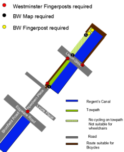
British Waterways’ 2007 proposals for comprehensive signage
The Warwick Avenue (Blomfield Road access point) map was clearly an afterthought, an economy measure, when the proposals for signage were dropped.
Since the surveys by London Canals (2006) and British Waterways (2007) the Little Venice-Camden towpath has gained greater prominence with an increased online presence (regular uploading of pictures, blogs, tweets, You Tube videos etc) and the relaxation of cycling restrictions, making this one of London’s most important cycle routes. Post-2012 (the Olympics/Queen’s Diamond Jubilee) the towpath has seen even greater pressure placed upon it, especially as it was also denoted one of London’s new important walking routes – the Jubilee Greenway.
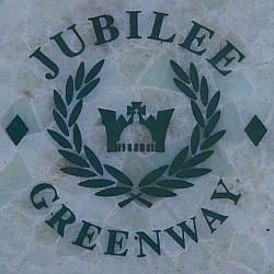
Jubilee Greenway marker
Essentially the substituted towpath section has to be the worst section of the entire Jubilee Greenway within central London, as well as the worst section of any of the London canal towpaths in the centre of the city!
In terms of accessibility, the main sections of towpath (Paddington basin westwards to the Grand Union and Pateley Street eastwards towards the Thames/Lee navigation) are let down by this dreadfully inaccessible section between Little Venice and Pateley Street footbridge. Its an outrage. Its not just British Waterways, now of course Canal & River Trust, but also the City of Westminster who have let this outrageous state of affairs perpetuate. Its an embarrassment even to walkers who have to take to using busy roads because they cannot reasonably use the substituted towpath, whilst disabled people/wheelchairs find this section a major obstacle course.
Undoubtedly its a most unacceptable situation especially in the centre of London these days. Its even more outrageous when we find that access has in fact been reduced – rather than enhanced – by the placing of moorings along Blomfield Road and taking away the original towpath’s potential. This was a mistake that was never corrected following the ‘Arklight’ debacle.
Part two covers a brief historical background to the substituted towpath and lack of alternative routes.


